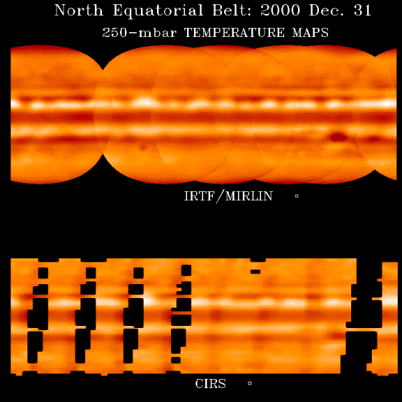
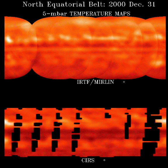
Thermal Imaging and Cassini CIRS observations
The accompanying maps of Jupiter's tropospheric and stratospheric temperature fields were taken by the NASA Infrared Telescope Facility (IRTF) and the Cassini Composite Infrared Spectrometer (CIRS) during the recent Jupiter flyby in Dec. 2000. The CIRS map is only filled in between 60˚ S and 60˚ N latitude, whereas the ground-based images are plotted from 90˚ S to 90˚ N. The spatial resolutions of both images are comparable.
The troposheric maps were made from observations at 18.6 microns and show temperatures near 250 mbar total pressure. Prominent waves are apparent just north of the equator and are easily tracked. The cold Great Red Spot is apparent in the lower right. The ground-based and CIRS observations show that the prominent waves are moving very slowly compared with the cloud-top motions.
The stratospheric maps were made from observations at 7.85 microns and show temperatures near 5 mbar total pressure. Banded structure, but of a different type can be seen. Being in its late summer, the northern hemisphere has been warmed up by incident sunlight, a fact that is evident in the maps.
The maps are still preliminary, with imperfections in the processing evident in the seams between individual ground-based maps, for example. Nevertheless, it is apparent that the correlations between the maps is very high. The spatial resolution element is shown at the bottom of each map.
Similar observations
of Jupiter has been obtained for over a decade in support of the Galileo
mission. These observations were obtained as part of a long-term synoptic study
of Jupiter to provide targeting information for Galileo as well as to
understand seasonal variations in the atmosphere of Jupiter. All of the images of Jupiter-- over 60,000--
have been archived in the Planetary Atmospheres node of the Planetary Data
System as a resource for future generations.